Collections

无人机技术与法庭科学的交叉融合
Sort by Default Latest Most read  
Please wait a minute...
  • Select all
    |
  • Research Articles
    FENG Lei, JIANG Xuemei, LU Xilong, LIU Jin, SUN Zhenwen, SHEN Yujie, CAO Yuhang, ZHAO Xingchun
    Forensic Science and Technology. 2025, 50(6): 551-555. https://doi.org/10.16467/j.1008-3650.2025.0069

    With the full advancement of the low-altitude economic strategy, low-altitude flight safety has increasingly become a top priority for national stability and security. Drone crimes are rapidly evolving from potential risks to real threats, with both the number of cases and the level of harm rising exponentially. In response to the critical challenges of drone governance, such as “difficulties with low-altitude surveillance, target identification, and timely disposal”, this article proposes to build a four-dimensional linkage technical investigation and prevention pathway of “global intelligent sensing network - three-dimensional forensic examination system - precise source tracing technology - coordinated rapid disposal”. This system, for the first time, proposes the focus of investigations on drone-related incidents, provides technical support for the high-quality development of drones, and provides systematic solutions to global non-traditional security governance.

  • Research Articles
    LIU Jun, LI Wei, FENG Hao, GUAN Chuang, WANG Shiyuan
    Forensic Science and Technology. 2024, 49(4): 389-395. https://doi.org/10.16467/j.1008-3650.2023.0072

    The on-site investigation of traffic accidents in China mainly relies on two-dimensional exploration methods such as camera photographing, ruler measuring and hand-painted scene map. The works including photographing, fixing and position measurement of key trace material evidence are often manpower and time consumption. However, long-term scene investigation will occupy the accident section and even interrupt traffic, which will easily lead to secondary traffic accidents. To address the problem of low efficiency and difficulty in scene investigation work of road traffic accident using two-dimensional surveying methods, the unmanned aerial vehicle (UAV) oblique photogrammetry technology is introduced to achieve efficient and comprehensive scene surveys. This method utilizes consumer-grade UAV to capture high-resolution scene photos with location information through aerial photography. These photos are then processed by three-dimensional reconstruction, resulting in the digital reconstruction of the accident scene. The effectiveness of the digital reconstruction is evaluated in terms of reconstruction precision, reconstruction effect, and operation duration. Experimental results demonstrate that for the accident scene with an area of 20 m×30 m, the merging and reconstruction of photo sequences taken at different aerial heights can achieve centimeter-level precision in dimensional measurements, with a relative error of +1.6 cm for a 30 m road distance. The reconstruction results exhibit a true three-dimensional effect, which clearly displays road marks, scattered objects, and more. Moreover, the scene operation duration can be shortened to less than 5 minutes. This method realizes the digital reconstruction of three-dimensional scene at traffic accident sites, replaces traditional photo-based surveying methods, significantly improves scene investigation efficiency, and facilitates the rapid processing of traffic accident scenes.

  • Special for the 13th Five-Year Plan
    HUANG Wei, ZHANG Yang, LIU Guangyao, ZHANG Zhicheng, HUANG Wei, LI Zhigang, XU Xiaojing, WANG Guiqiang
    Forensic Science And Technology. 2020, 45(4): 331-334. https://doi.org/10.16467/j.1008-3650.2020.04.001
    Objective To probe into the feasibility and accuracy about the UAV(Unmanned Aerial Vehicle)-carried hyperspectral imaging system to find and recognize the bloodstain on the surface of bitumen road so as to provide a new approach for the application of UAV into criminal investigation. Methods The rotor UAV, equipped with the coaxial reflection convex holographic grating hyperspectral imaging system, was used to collect the visible and near-infrared spectral imaging data of human blood, paint, soy sauce and other sampling traces on the surface of bitumen road. Different algorithms were selected to analyze and tackle the collected spectral imaging data. Results For the human blood, soy sauce and paint, their reflectance spectra are significantly different in the waveband of 600~800nm. With adoption of the spectral angle mapping algorithm and the related maximal angular threshold set to 0.1 radian, the UAV, flying at 30m high, can harvest the spectral imaging data of 12000m2 scanning area through its one single takeoff and landing. Consequently, the bloodstain can be accurately discerned from the bitumen pavement if it is of the size over 4cm × 4cm, having been distinguished from paint, soy sauce and other traces. Conclusions The UAV-carried hyperspectral imaging system is applicable for crime scene hunting to discover and/or perceive biological evidential materials, e.g., the bloodstain.

  • Technical Notes
    YAN Yuwen, YU Tao, LIU Guanhua, LU Xilong, LI Zhigang, WANG Mingzhi
    Forensic Science And Technology. 2020, 45(3): 311-316. https://doi.org/10.16467/j.1008-3650.2020.03.020
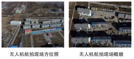
    For the crime scenes, both azimuth and overview photographing/video-recording are required, yet the traditional manipulation is of limitations, e.g., difficulty to find the suitable shooting height/spot around the crime scene, restriction of visual angles at the shooting spot and some dangerous scenes to prevent investigating photographers from entering. Unmanned aerial vehicle (UAV) brings opportunities and promise to overcome the above problems since it excels in good handling performance, flexibility, wide range of environmental adaption and high image quality when it is fixed of man-controlling camera. Here, the introduction was at first conducted of UAV about its basic principle and manipulating methods, with the summarization being put through the actual applications where three suitable typical application scenarios were especially expatiated, the large-scale explosion scene, the high falling scene and the low-lying scene. Successively, the specific operation methods and precautions of UAV were illustrated in combination with the exampling cases of applications at typical crime scenes. Finally, an analysis was carried out on the possibility for UAV to photograph the key areas/subtlety of crime scene, with the applicable prospects of UAV being discussed in the future crime scene investigation.
  • Applied Researches
    LU Xilong, LIU Guanhua, YAN Yuwen, SHI Yi, ZHAO Xiaohui, SUN Zhenwen, LI Zhigang, LIU Jin, WANG Mingzhi
    Forensic Science And Technology. 2018, 43(6): 477-480. https://doi.org/10.16467/j.1008-3650.2018.06.011
    With the continuously expanding applications, UAV (unmanned aerial vehicle, UAV) has been playing a more important role into China’s policing. However, UAV, as a flight platform, cannot fully meet the needs from the current crime scene investigation when it is only equipped with the aerial photographing and mapping equipment. The authors designed such one installation that UAV was respectively equipped with a mechanical arm, vacuum pump, light source or an infrared recording equipment while operated under the corresponding control program. Such installed UAVs have realized to discover and extract the evidential materials of solid, liquid and gas, successfully taking photographs and video-recording under low illumination. Through the applications of actual and simulated cases, UAV technology has proved that it can significantly improve the crime scene investigation on its quality, efficiency and safety under special conditions. Therefore, UAV provides new feasibilities for crime scene investigation to come forth novel initiatives and innovations, inspiring people to think of new ways for future researches to utilize UAV into forensic practice.
  • Forum
    SUN Zhenwen, LIU Guanhua, WANG Mingzhi, SUN Yuyou, ZHANG Ning
    Forensic Science And Technology. 2016, 41(5): 398-401. https://doi.org/10.16467/j.1008-3650.2016.05.013
    With the continuous decline of production cost and improvement of performance, the unmanned aerial vehicle (UAV) industry has developed rapidly from high-end commercial use to mass market in recent years. UAV has the advantages of small size, light weight and easy operation so that it can be deployed to make reconnaissance and/or attack, photograph and transmit, deliver goods and conduct scene intervention. Until present, UAV has been widely used in public safety, accident rescue, forest fire prevention, geologic exploration, aerial photography, environmental protection and others. UAV aerial photography is to take photos of the ground and objects from different heights and/or angles by the UAV equipped with high-definition camera plus video and wireless video transmission device, being categorized into the low altitude photography that is permitted to carry out at a height less than aviation control. This paper explicates the on-going application of UAV aerial photography in crime scene investigation and prospects its development trend.